Showing posts with label measured distances. Show all posts

Monday, October 4, 2010

Reflections on the Blues Cruise 50k

Yesterday, I ran the Blues Cruise 50k. It was my first real foray into "ultra" marathons – a category that includes anything longer than a marathon, from 50ks to 50-milers to 100-milers and up.

My main impressions:
-It was a beautiful day, a perfect day, really, blue skies and sunlight but cool and breezy.
-The course itself was beautiful, along a lake, trails that were usually runnable
-The support was great
-Toenails, though small, can cause an enormous amount of pain
-I'm happy with my finishing time
-Ultra running just isn't for me.


50k translates to 31 miles, which makes sense, since a 5k is 3.1 miles. This course may have been only 30 miles, though, which translated to around 48.3k; Bob Reynolds also ran this with me, wearing his gps, and that was what he had.
"Only 30 miles" – it was still a long, long way to run.

The race started out well. It's an out and back, on trails that are often nice, frequently beautiful, at times breathtaking. Most of the trails were runable; there were a fair amount of short and really steep hills, which were a challenge (both up and down), but they were never too long. the one real significant hill was at around mile 10 (and then 21, seeing as it's an out-and-back), but that was not quite as steep, a hill that would have been more Wissahickon-like.
I started off a bit fast – first mile around 7:30, no way that was sustainable – and then settled into what seemed like a good pace. I hit the turnaround at around 2:02. I knew at that point that I was going to positive split the race, but was hoping for something around 4:10-4:15. Running that far, even on trails, beats me up, so equal effort = positive splitting.
I hadn't prepared for the excruciating pain that I was going to have to go through in the second half. I first noticed it going up the big hill at around mile 21. I'd felt something similar the Saturday before, on my weekly long run, and chalked it up to poor sock choice. I tried to run through it, but it would keep getting worse. I took off my shoe and rearranged my sock, which helped for a bit – I'd wind up doing that 3-4 times during the race. At a late rest stop (mile 25) I managed to get some ibuprofen, which also helped for a bit. But nothing that helped lasted. I think that at the last rest stop – maybe 3.5 miles out? - if I'd known how much I'd hurt during those last few miles, I'd have DNFed. Lots of grimacing, yelling, deep breathing till the pain subsided, then starting up with the first ginger steps, till up to running pace, then I'd land wrong and the pain would begin again.
That said, I'm glad I finished. Now I've done it – I've run at least one ultra. And my time was good – 4:32. A pretty pathetic 2nd half, but an overall good time. That was good for 19th place out of around 200 runners. I'm usually in the top 5%, but I expected to be somewhere around top 10% for my first ultra. And it was around the time I'd been guessing I'd get.
But I don't think that this is for me. I can't blame the venue, can't blame the weather, because I couldn't ask for anything more. I don't know that I can blame my toes - I mean, I can, but I suspect that during most ultras I'd have some issue or another. But 30 miles, 31 miles, even 26 miles – it's just a long way to run. While running that long has the advantage of letting you see a lot of beautiful scenery, and taking this a bit easier, you don't need a race for that.

Sunday, September 12, 2010

A Quasi-Marathon, and some thoughts on strategy

I ran in the Trail Dawgs' Stumpy's Marathon this morning – a no-frills affair through some nice woods outside of Newark, Delaware.
I didn't fully race it, and it's not fully a race. It's a supported run, with no real clock, no sign-up, and no guarantees. It's a free race and, while they like pointing out that you get what you pay for, it's a pretty good event. They had a bunch of rest stops, and did a decent job of marking a pretty complicated course. Bob R drove down with me, and I ran with him for the first 20+ miles. He wore a GPS, and had the route at 26.6 miles. Or maybe 26.8 – I forget.

It took me just under 4 hours. I break down the race like this: first two hours were fun; the third was difficult; the fourth hour was a brutal death-march. I didn't walk (with the exception of some steep climbs, where it was a good choice), but was really feeling the pain.
For the first three hours, I'd tried to run with Bob, even though I know that he does a lot more long-distance training than I do. Seemed more pleasant to run with someone, and it was good to have help finding the mile markers. For the first two hours that was easy enough. The third was a struggle. By hour 4, he left me in the dust.

It made me think more about the races I've done recently: Double Trouble, Half Wit, and this quasi-race. I'm ok with all of my results. The one that most disappointed me was half-wit. That was the only one where I'd made a conscious choice to negative split. The thing is, though – even if it cost me some time, it was the one event where I really felt like I finished strong.

Positive Split, Negative Split... there's a lot that makes sense about positive splitting a trail race. I'm not sure that my positive splitting cost me any time in Double Trouble or today (or that I should care much about the time today). But it's hard to deny that it makes me enjoy the running less.

My next race – a real race – is the Blues Cruise 50k. That'll be the farthest I've ever run. I'm thinking I should start off slower.

Saturday, August 14, 2010

So THAT'S What It Looks Like

Tomorrow is the Half-Wit Half Marathon.
In the past I have criticized this race some, but really, this is one of my favorite races, one that I look forward to a lot, one that Helen and I plan around.

My main criticisms in the past came from going off course the first two times I ran it - for reasons that I thought were avoidable by better signs and better volunteer placement. Nor does the RD make the course available ahead of time. It's a trail half marathon, and while I do think it's pretty close to the distance, it's not like these things are USATF certified. I'm not sure that an official map exists.

Last year was the first year I was able to run the race and not go off course. I paid attention, tried to remember what I could. I also got lucky some. But as this race was approaching this year, Helen suggested I look on-line, that maybe someone had posted a GPS file of the course.

She was right! A few people had, and I was able to look over the course some. And my main reaction?

I had no idea, none, that it looked like that.

It's a really long, narrow course. Who knew?

Running in the Wissahickon can be disorienting, but I know its boundaries. And it's got the creek running right down the middle. Without knowing the roads around the half-wit course, I just had no sense at all.

Will this new-found knowledge help? I'll find out tomorrow.

Wednesday, July 7, 2010

Which is the bread, which is the butter?

A busy last few days of running and biking. On Saturday, met up with the usual Saturday Morning Trail Run down at Valley Green. Some guys were running the four corners; I wasn't up for all four, but did join them for two.

Sunday, I got out on the bike, and did the most recent version of the bread and butter loop. It wound up around 75 miles.

Then Monday, the Third Annual Green Ribbon Trail run – the fourth-of-July tradition of running someplace that isn't the Wissahickon, with the guys that I usually run in the Wissahickon with.

And I realized, a few things have changed in the last year or so. To start, a few things have happened to the bread and butter loop over the last year or so.

The bread and butter ride is the one that I developed, bit by bit, when we were still living in C-Hill. It was a 65 mile route that included a 35-mile out and back, which was ok, and a 30 mile loop, which was pretty awesome. No surprise: I called it my bread-and-butter because I would do it so often. Sometimes it seemed like I rode it most weekends, at least when the weather permitted. One winter, the weather permitted pretty much through December. That was fun.

Moving to Mt. Airy meant that the route got longer. This alone would have knocked it up to around 70 miles.

I added on a few more miles above that, because I found a nicer way to start the route. It's now closer to a loop; there's only around 5 miles that I do both ways (and even that's avoidable, if I want to do a few miles on route 113). And the additions are nice; more woods, less traffic, and a section that goes through Evansburg State Park. There's also a section on this odd trail that goes under the powerlines.


But the biggest change to the bread-and-butter route? I just don't do it that much anymore.
This was only the second or third time I've done the whole thing since the start of spring. It's hard for me to get out on my bike as much as I'd like. The little jump in mileage, from 65 to 75, doesn't help; but mostly, I think it's my shift in focus. I'm running more, I'm biking less. I'm ok with that. It's just so much easier to lace up the running shoes and head out. I can run in the 'hood, I can head down into the woods. I can run by myself, with Helen, with other wanderers... For a bike ride, there's just so much more planning involved, and so many more limitations. So many roads that are un-fun to ride on. And I like riding on the path, but it gets old.

Meanwhile, the 12-mile run on Saturday – that felt pretty easy. Familiar paths, familiar faces. It felt more familiar than anything I've been doing on the bike lately.

That said, the ride on Sunday was a lot of fun. Especially the part going through the woods out by Swamp Creek, alone on the road, with the sun shining through the trees. That was pretty awesome. It usually is.

Monday, August 18, 2008

Friday's Ride

Helen and I were up in New England last week, on an abbreviated version of the Vermont/Great Barrington trip we've taken before. We got to revisit some things we've done before – running in the Beartown State Forest, riding up from mom's towards Tunbridge, running on the off-roads outside of mom's village. (Helen did much better on that climb than she did 2 years ago, just pedaled right up it). Some of my favorite biking routes are up there, both near Great Barrington – where we didn't have time to ride this time – and up in Vermont. My ride on Friday, though, was largely new areas. I'd wanted to do that, see stuff I hadn't seen before. This was my most successful ride yet on the other side of the White River towards Woodstock.


Distance: just over 50 miles

Time: probably around 4 hours, including stops to eat

Lowest elevation: 223

Highest elevation: 1614

Really Big Climbs: Hard to say, but 5 at most. The ride from mom's house to and from Sharon is one big up and down. Once I crossed the White River and went up Howe's Hill Road I was climbing for a while, from around mile 7.5 to 10.5, then again, after a significant downhill, from 11.5 to 13.5, although this one wasn't as hard. In general, the hills I was on across the White River weren't as hard as I expected. Miles 17 to 22 was pretty steady climbing, much of it on a packed dirt road that I was glad to be going up and not down. After that it was a fairly gradual (by VT standards, anyway) descent down into Bethel. Really, from mile 22 until mile 43 I was either going down or riding the relatively flat roads along the White River. That said, I'd probably say that the section from mile 26 to mile 38 was the least favorite part of the ride; the most traffic, the least scenery. It also goes through Bethel, which is surprisingly ugly for a Vermont town. The last section along the river, from South Royalton to Sharon, there's a little road on the other side of the river that's nice. But riding on routes 12, 107, and 14 – it's not as nice as the other roads in Vermont. The two hardest climbs, it turned out, were the ones on 132, which I'd done a bunch of times before.

Highest speed: 47 mph. A new record for the black bike. (Red bike hit 50 mph once, also in Vermont, on a downhill I'd hoped to get to this vacation but didn't). The 47 mph was going down 132, on the home stretch. I got up to 44 earlier in the ride, somewhere around mile 14, but there was a car coming in from a side road so I couldn't fully let loose.

Pictures taken: 0. Sorry! No camera this trip.

Overall, a nice ride. Some of the roads are ones I want to get back to. The loop itself needs some tweaking. I'd like to find a way to include the first miles and the last, but cut off some of that middle stuff – maybe find a way to cut back to Royalton instead of Bethel. It's tough to figure out these routes, though, since you never know when you look at the maps whether a road is paved or not. You don't always even know when you turn onto a road, since a lot of roads start out paved and then turn to dirt – this was the case with Stage Road, which I took in the middle of the ride. Again, a decent road to go up, but I wouldn't want to go down it. I passed a road that was called Royalton Turnpike. I can't help but think that the name was ironic.


Wednesday, December 5, 2007

Bread and Butter pics - part II

Part II of the pics of my ride.
Incidentally, I'm told that the interesting part of my ride starts in "Lansdale" and not "Landsdale," which seems believable.

On to the pics.

Barndt road. This is from a stretch on the shorter of the two loops.

This is a section of "Lonely Road" - truth be told, it's no lonelier than most roads out there.
The street sign. No, I don't think it's "that" Ridge road. Which is an avenue, anyway, maybe a pike. And well south of there.

I blew it on this next pic, I'm way too far. The road sign says "gameland road," and the larger sign says something like, "welcome to state game lands, hunt safely." This is on the longer loop, and it's the scariest part of the ride. I sometimes sing aloud on this section, making up songs about how I'm not game:


Another nervous part of my ride, and another blown pic. The road sign there says "gun club road." I do hear shots, although I suspect they know what they're doing. This is on White's Mill Road, I believe. From the shorter loop:
Another section of White's Mill Road:


This last pic is Swamp Creek Road. Hard to capture what a pretty road this is, or how fun it is to ride on it, but I like the Dali-esque feel to the photo.


Well, that's that. Right now it's all covered with snow, but I'm hoping soon to be back out there.

Bread and Butter – Now With Pics! (part I)

A few months ago, I posted on my "bread and butter" ride, a 65-mile loop starting at my house, heading out to Landsdale, then out through a lot of mostly farm land. I've actually got a few variations, although they're all fairly similar. It's a lollypop ride, which can be anywhere from around 63 to maybe 73 or so miles long. It really gets nice after Landsdale.

I'd been planning on bringing a disposable camera for a while - and last week, judging by the trees in my 'hood, seemed like the perfect time.

.

Turns out, further NW of the city, the trees weren't as vibrant – they're a bit further along, it seemed. But these pictures are actually more representative - they really capture the late fall feel of the route.

These are the two varietes – I skipped the 15-17 miles (one way) taking me from our house to Landsdale. (Click on the photos for the gmap).

The shorter route:

The longer route:


The pics make the route seem flatter than it is, but it's by no means mountainous.

Anyway, without further adieu, the photos:

Landsale, Kriebel Road, I believe:

right nearby:

I've always had a certain fondness for this little building, since a time around 5 years ago when I waited out a thunderstorm in it.

Indian Creek Road:

I'm a sucker for photos of old school farms:


Wednesday, October 24, 2007

Favorite Climbs

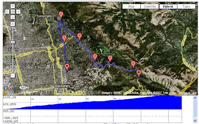
Having posted the gmap of my ride in Vermont, it got me thinking about some of my favorite climbs/descents. I like riding in Vermont because I like hilly riding, even mountainous riding. The riding I do in Philly isn't flat, but it's not at the Vermont level.

Except for the Schuylkill river path. That's flat.

There are hills on all my other rides, though. Rides tend to be rolling. What I miss is that long-term, you're-gonna-be-here-a-while climbs. And I miss the downhills, too. I'm a woos on the downhills, but I still miss them.


Some of my favorite rides/descents are up by my mom's place in Vermont. But my favorite riding was when I lived in Berkeley. That was just amazing riding, right out the door. (It's right out the door at Mom's, too, but that's all there is there).

I didn't make a very good Californian, but I loved the riding.

This was the start of my bread-and-butter.


Up Spruce, over Grizzly Peak. For the whole ride, I usually continued over to Claremont and down into Oakland. Only wound up at 17 miles, but always felt like a great workout. I also went up Euclid a lot, which is "parallel" to Spruce (neither is particularly straight, though). Spruce is a bit more gradual, Euclid a bit steeper. I'm guessing I did around 60% Spruce, 40% Euclid. Of course, there was always the option of going straight up Marin:


I did that once. A lot of people do it once.

On longer rides, towards the end was my favorite climb – Pinehurst, from Canyon to Skyline. I always liked the names involved there. Pinehurst means nothing, but Canyon and Skyline are just the kind of roads they sound like. (Although, earlier in those rides, I was often on "Happy Valley" road, which is neither). I think in all the times I rode Pinehurst I saw 3 cars. There's just something cool about riding up a switchback.


-----

In Vermont, most of my rides involve route 132, between South Strafford and Sharon. South Strafford is around 400 feet higher than Sharon, but it's actually the ride to Sharon that's harder. Sharon to the top, it's just kind of a slog, but never really steep. It even feels kind of flat in the middle of the climb. Going out of mom's village, it just climbs right away.

Then there's the climb between Bethel and Rochester. That's on another level. I did this last year as an out-and-back. The start of the descent into Bethel is the only time I've ever reached 50mph on my bike.

I've never walked my bike up any of these routes. I'm proud of that. I did walk my bike down Claremont once, but that was because of a flat tire. The closest I came was last summer, heading toward Rochester, when I had to stop a couple times and catch my breath.

None of these are the Alps, none are the Pyrenees, none of these would get me the polka-dot jersey. But the feeling of accomplishment of making it to the top of these climbs is hard to beat.

Monday, August 6, 2007

Of Prunes and Bats

As a result of excessive prune eating, my stomach was turbulent yesterday. I waited until 8:30 pm to make my run happen. Noah suggested that I do a small loop first. That way, I am never too far from home in case I have to go. It sounded like a good idea, so I headed out, adopting the mentality of “one mile at a time.”

I chose to start downhill, because downhills shake things up. If I have to turn around for the bathroom, I’d rather go uphill and not shake things up. Everything happens for a reason. So, I ran down to Mt. Airy at an easy pace, and after a mile, I felt that if I maintain this speed and effort, I probably would be okay running nine more miles. So, I hooked up with the 10 mile route we took one week before the marathon with packed snow on the ground, a tour through the outer parts of Mt. Airy and Chestnut Hill.

With my stomach mostly calm, I had the nightly things to worry about, namely: (1) darkness, (2) headlights, and (3) bats. The part of the run through Chestnut Hill was spooky. The streets are empty and dark, thanks to the trees that grow under the street lamps. I could barely make out what I was stepping on, which was mostly rocky sidewalks. Stepping through this region, I was reminded that I own headlights, and had I remember to bring them, I would've been spared this blair witch experience.

When I got to the McCallum Street Bridge, I decided to switch on to the road surface, which is much smoother. That was a bad idea. One car swooshed by and decided to yell loudly into my ear as it passed, even though I was running on a different side of the street. Forget Mace, I wish I had a horn to startle them back. Then, several cars turned on their high beams as they approached, completely blinding my eyes. Cars: There is no need for high beams straight on. In fact, cars are supposed to switch to low beams if they see another car approaching, so as not to blind the drivers. But apparently, runners' eyes have immunity. Not. Do I need to wear my sunglasses at night? I put up my hand in a visor-light gesture. I just felt like being rude.

Fortunately, I remembered that I have some music by Girlyman with me. I put on their new CD, pushed up the pace, and ran up Seminole Road towards the northwest corner of the gun loop. I calmed down a bit, but then I started hearing this loud squealing sound from all directions. "epppp....epppppp.....eeeppppp." It wasn't a halloween tape, because not all houses can have the same tape. I ruled out “sim,” this insect that gets noisy at night in Hong Kong. And I just know they're not birds, even though I couldn't see them. I was totally scared. This area normally feels kinda enchanted, but today it was as if I was wandering in a zoo at night, with the animals out of the cages and the zookeeper asleep. Seriouly, a mouse crossed the street right in front of me. The sky started to rain. And I was left to conclude that the sounds came from waterproof bats.

I hurried home. And last night when I slept, I dreamt that Agnes, who does not read Harry Potter, reads Harry Potter. Weird.

Tuesday, June 19, 2007

Long run in Great Barrington, MA

http://www.gmap-pedometer.com/?r=1061708

We're in Great Barrington, MA this week. Today's run was a 13.5 lollipop route between Great Barrington and Sheffield. We ran through residential areas, farms, covered bridges, rivers and ponds, with mountains in the backdrop. The run itself was more rolling than hilly, and from time to time we got to run on a soft dirt path instead of paved road surface. This is definitely better than the long run routes we tried last time we were here, although I wouldn't mind having more shade on a hot day like today.

Thursday, June 7, 2007

My Bread-and-Butter

Helen posted her bread-&-butter routes a few weeks ago, so I figured I'd post mine.

Mine is longer, but that's because I do it on a bike!

I do a lot of my riding out in and past Lansdale. Some of my rides are more explorative, as I like to think of them as 'riding' and not just 'training.' So, often, I'll do some variations. Some work out well and some, not so well. Not so well usually means that I wind up spending a lot of time on major roads.

The route here is the one that I've worked out as a really good, 65-70 mile route. I've always thought of it as a lollipop route – an out and back, with a loop at the end. But, as Helen points out, it really looks more like a kite on a string.

From http://www.gmap-pedometer.com/?r=1015299

Monday, May 14, 2007

My Bread and Butter

I had planned to do 8 miles on the trails yesterday morning before meeting up with friends in town and then family for Mother's Day. But I also had errands to run that included killing bugs and driving a stick-shift car around. Due to my slow driving adventures in the morning, I ditched the trail run and did two shorter runs.

Run #1
In the morning, I ran down to Mt. Airy in a 4-mile loop that dips into the East and West sides of Germantown Avenue. Most of my Mt. Airy runs are some variation or extension of this loop. It's the bread and butter of my winter road miles since moving up here. The only thing special about today's run was that I went with the bare bones four, and also that I managed to sneeze ten times in a row, starting from Chew and Sedgwick and persisting until after I passed the Acme.

On a cool and sunny morning like this, with a few Simpsons clouds hanging up in a perfectly sky blue sky and not many people up yet, it was hard to stop at just 4 miles. At the end of the loop, my inner child was pleading for me to stay out running, protesting my brunch plans being so early, but fortunately, my bladder was more vocal and decided at that moment that I had to go inside. So, that's that.

Run #2
It was clear that after a day with seven sittings in the car, I needed this second run. Need is not a strong word here. So at around 9:30, I laced up the shoes (yes, laced!) and put on the shorts Agnes just got me for my birthday and did the gun loop. The gun loop is a five mile loop shaped kind of like a gun around Chestnut Hill that includes a long hill at mile 3. Getting good at this hill has been a goal of mine since riding a bike down the hill on a fun ride with Noah a year ago. I can't say I'm good at it now, but I am competent. There's a short cut of the hill that goes through a small street where Dhani Jones used to live.

I love running on a Sunday night. There were hardly any moving cars on the streets and everything was calm and quiet. It felt like I was bouncing through a ski town in the summer, and I could look into the cute houses that line the streets with anyone staring back.

My left hip was a bit sore at the end of the run, most likely from the bike-run-tennis trifecta yesterday. It's okay, because Monday will be a rest day due to work's surprise phonathon.

I gmaped the two routes:

Thursday, May 3, 2007

FDR Park run with Leah

I went on a nice run with Leah today in South Philly. We ran from Broad and Oregon down to the entrance to the Naval Yard, made a U-turn, ran one loop of FDR Park, and back up to Oregon. Total distance was around 3.5 miles. It was nice to catch up with Leah on school, running, and her volunteer trip to Palestine this summer. I miss runs like this where we could just not think about the legs moving and just say what comes to mind and process the day's events, vent if needbe, and relate to another person. It was as much a social opportunity as it is about running.

We also got to check out the last two miles of the Broad Street Run course, which indeed features an incline for a quarter mile around mile 9. I knew there was a reason (other than going out too fast) that I run out of energy around here every year.

For future refernce, the link here maps the loop inside FDR park, which is 1.63 miles long: http://www.usatf.org/routes/view.asp?rID=21300

Saturday, April 28, 2007

Hills, Hills, Hills

Elevation profile of today's run:
(between 70 ft to 370 ft again and again)


Click on the map below for the route:
(11.33 miles)


I wanted to get in some distance, some fast running, and some uphills and downhills today. This route goes from Chestnut Hill through Valley Green to Roxborough, then through Shawmont to the Schuykill River, up Harts and through Whitemarsh and Andorra, down to Valley Green and back to Chestnut Hill. It's a pretty simple and boring route, but because I don't do it often and the hills are long, I end up finding it interesting. Much of the time, I was just in a zone, with the scenery passing by me in my peripheral vision. Today's total: 11.33 miles in 1 hour and 27 minutes.